The territory of Tajikistan from the most ancient times lay on the important historical routes of the Silk Road, connecting the East and the West. Country in the international trade and cultural exchange linking of old possessions of Bactria – Tokharistan (Chaganian, Shumon, Ahorun, Kubodien, Vakhsh, Hutal, Rasht, Kumed, Darvoz, Vanj, Rushan and Wakhan), Soghd, Istaravshan (Ustrushan) and Ferghana with India, Afghanistan and China. The Silk Road was not only the exchange of goods between the East and the West, but also ideas, cultures and people.
Modern Tajikistan is a mountainous country with the altitudes varies from 300 to 7,495 meters above the sea level. 93% of the territory are mountain ranges relating to Pamirs, Hissar-Alay and Tien-Shan mountain systems. The mentioned ranges are divided by rich and fertile lands of Ferghana, Zerafshan, Vakhsh and Hissar valleys. Complicated relief and big amplitude of mountain system’s high caused exceptional diversity of flora and fauna.
Tajikistan is a country of high peaks, strong glaciers, swift rapid rivers, unrepeatable in terms of beauty lakes, unique flora and rare animals. Mountainous, floor landscape determines originality and peculiarity of Tajikistan’s nature, riches of its forms called for life by diversity of climatic zones. In the republic it is possible during the one and half hour fly from heat of Vakhsh valley and get to arctic cold of everlasting snows of the Pamirs. On the basis of the existing 13 state nature reserves and sanctuaries “Zorkul”, “Romit”, “Mozkul”, “DashtiJum”, historical and natural park “Shirket” and the Tajik National Park the unique ecology, landscapes and natural monuments in its original form are preserved.
Priority modes for international tourism in the country are considered to be:
- Climbing, mountain sports and ecotourism;
- Rafting, paragliding, skiing, ski mountaineering;
- International hunting;
- Historical, cultural and ethnographic tourism;
- Spa treatment and rest;
Top 5 Destinations in Tajikistan
Dushanbe
Dushanbe, the capital of Tajikistan, serves as the country’s largest city and a hub for its scientific, cultural, economic, and industrial activities. With a population exceeding 1 million in a country of about 10 million, Dushanbe is an important focal point.
Situated in Tajikistan’s southern region, within the Hissar Valley, Dushanbe experiences a subtropical inland climate. Summers here can be scorching, while winters are generally brief.
“Dushanbe” translates to “Monday” in Tajik—a nod to the city’s longstanding tradition of hosting bazaars on this day of the week. Covering nearly 130 square kilometers, the city is bisected by the Varzob River, also known as the Dushanbe River. The nearby Varzob Gorge is a popular destination for both locals and tourists.
Dushanbe today is a cosmopolitan city that hasn’t lost touch with its cultural roots.
Top attractions in Dushanbe are:
- The statue of Ismail Somoni – the large monument commemorates the 1100th anniversary of the Samanid State, the heyday of the Tajik nation when science and arts flourished.
- The Navruz Palace – the largest tea house in Central Asia.
- Rudaki Park – dedicated to the great Persian poet Rudaki, who also lived during Samanid time in the 9th century AD.
- Flagpole – The second tallest flagpole in the world.
- Palace of Nations or the Presidential Palace – is the official residence of the President of Tajikistan.
- The national museum of Tajikistan – is a museum in Dushanbe, the capital city of Tajikistan.
- The National Library of Tajikistan – is the main library of the country, specializing in preserving cultural heritage of the peoples of the Republic of Tajikistan.
- Mehrgon Market – is a new and modern food market in Dushanbe the capital of Tajikistan.
- Independence and Freedom Monument – was opened in 2022 in honour of the 31st anniversary of Tajikistan Independence.
The statue of Ismail Somoni – most impressive statue in all of Dushanbe is dedicated to who else but Ismoil Somoni – the national hero of Tajikistan. Ismoil Somoni was the most powerful Persian leader during the Samanid reign in the 9th century. The statue of Ismoil Somoni stands in front of a golden arch and is one of the main eye-catchers in Dushanbe. In summer, you can find many people walking around in the evening to enjoy the cooler temperatures after sunset. The statue can be found at the corner of Rudaki Park and frequently forms the center of events during important national celebrations and parades.
The Navruz Palace – going from the Flag Pole Park across the Varzob river, you stumble upon the largest tea house in Central Asia. The building actually has little to do with a traditional tea house. You can obviously go for a cup of tea, but there are also other types of entertainment inside, even including a cinema. With its decorative architecture and interior design, the tea house is frequently used to receive foreign dignitaries during state visits. The Tajik name for the tea house (Кохи Навруз) literally means Navruz Palace, which is quite an accurate description for its splendor.
Directly behind the Navruz tea house, there is a small artificial lake with yet another park next to it. The main sports complex of Dushanbe is located right across the road from the tea house, with the main football stadium. If you like, you can even go and play some table tennis.
Rudaki Park – for a capital city, Dushanbe can be considered quite an oasis of greenery. Innumerable tree-lined avenues, parks and public gardens are scattered throughout Dushanbe. One of the nicest patches of greenery is Rudaki Park, which lies right in the center of Dushanbe. As the name implies, the park is named after Rudaki, who was a renowned Persian poet that lived in the 9th and 10th century. A statue dedicated to Rudaki is located in the heart of the park. The park is surrounded by numerous impressive buildings, including the national library and the not-so-modest presidential palace. A mishmash of lights transforms the park at night into an interesting place to wander around.
Flagpole – the second tallest flagpole in the world after the one in Jeddah, Saudi Arabia is here. In fact, as the flagpole was erected in 2011 dedicated to the 20th anniversary of Tajikistan, it was the tallest flagpole in the world with its 165 meters and held this title for three years.
Palace of Nations or the Presidential Palace – The Palace of the Nation is the official residence of the President of Tajikistan. It is located on Shirinshoh Shohtemur Street in central Dushanbe. The Presidential Palace is surrounded by Dushanbe Flagpole to the north, Rudaki Park to the east, Independence monument to the south and Varzob River to the west.
The national museum of Tajikistan – There are several museums you can visit in Dushanbe. Arguably the best is the National Museum of Tajikistan situated right inside the park of the flagpole. The museum showcases a variety of exhibitions spread over multiple floors. The bottom floor is dedicated to everything related to the Tajik nature, from geological rock collections to the wildlife that can be encountered in the mountains. The middle floor displays a wide variety of archaeological items of interest from the rich history of Tajikistan. A collection of ancient and contemporary art can be found all the way upstairs. The national museum is opened for visitors every day.
The National Library of Tajikistan the largest in Central Asia – located in Dushanbe, Tajikistan is the main library of the country, specializing in preserving cultural heritage of the peoples of the Republic of Tajikistan. While the original library state library in Dushanbe was founded in 1933 and named after Persian author Ferdowsi, the new national library building opened in March, 2012 alongside its new official name. The new nine-story building features 15 reading halls as well as over 20 departments. Access to the library is free to any Tajik citizen and foreign citizens with a Passport.
Mehrgon Market – It would be inconceivable for a city like Dushanbe not to have bustling bazaars like its multifunctional Mehrgon open air market. Named in honour of the annual autumn harvest festival, this monumental two-floor building attracts residents and visitors looking for authentic flavour and great bargains. Agricultural fairs and seasonal festivals such as the festival of grapes, melons, pumpkins, potatoes, and more are held at Mehrgon.
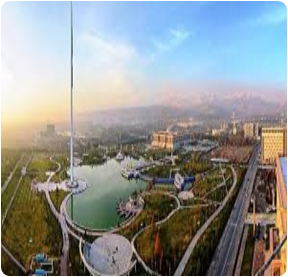
Independence and Freedom Monument or Istiqlol Complex – Istiqlol (Independence) Square was opened in 2022 in honour of the 31st anniversary of Tajikistan Independence in 1991. Istiqlol Tower is situated inside Istiklol Square complex. The 121-meter height of “Istiklol” tower is symbolic, that is, the lower part of the complex is 30 meters, a symbol of the 30th anniversary of State Independence, and the upper part 91 meters personifies the gaining of Independence in 1991.The total area of the symbolic “Istiklol” complex is 11,900 square meters. Archways in a baroque style with traditional Tajik elements mark the entrees to the complex. The park and square are publicly accessible. You can go all the way up to the top (14th floor) for a 360 degrees’ view over Dushanbe. On the lower floors, there is a museum with some general expositions about Tajik culture.
Khujand
Khujand is one of the oldest cities of Central Asia, according to some sources it was founded in the VII-VI centuries BC. It was conquered by Alexander the Great, who rebuilt, fortified and re-named it to Alexandria Eskhata (Extreme). Located on the Great Silk Road, and connecting Samarkand with Fergana Valley, Khujand enjoyed a favorable geopolitical location and significant transport importance. Later, it was conquered by the Arabs (in the VIII century), and then it maintained resistance to the army of Genghis Khan, but eventually was destroyed (in the XIII century). However, very soon the city revived, becoming one of the largest commercial, cultural and scientific centers of the Central Asian region. And even today, Khujand is an important industrial, scientific and cultural center of northern Tajikistan.
Khujand, occupying, mainly, the left bank of the Syr-Darya River, is surrounded by mountains with the slopes planted with orchards. A few kilometers upstream, there is a place where the Kayrakkum reservoir starts, stretching for 55 km. The Khujand citizens and tourists like to go swimming, sunbathing or fishing on the lakeside. The city’s climate is as beautiful as nature – the hot summers are softened by the winds and the waters of the Syr-Darya, while the winters are mild with little snowing.
As a thousand years ago, nowadays Khujand still plays an important transport role. The city is crossed by the shortest route, coming from Central Uzbekistan to the Fergana Valley, and afterwards to Kyrgyzstan. The city has a railway station, as well as an airport located 11 km from its center. The nearest major cities are Bekabad (40 km to the west) and Kokand (140 km to the east).
Being home of famous scientists, writers and musicians, Khujand preserves the status of the scientific and cultural center in Tajikistan. The city has a theater, regional history museum and an archaeological museum as well as the Khujand State University, with an enrollment exceeding 10,000 students from all over the country.
Khujand managed to preserve some monuments dating back from the XVI-XVII centuries – the Sheikh Muslihiddin Mausoleum and Jami Masjidi Jami Mosque as well as Khujand Fortress, which was built together with the city more than 2,500 years ago, and underwent several stages of complete destruction and restoration.
And today, following the tracks of the Great Silk Road, it is impossible to travel in Central Asia without visiting Khujand, the city which become a corridor in the snowy mountains.
Top attractions in Kulob are:
Mausoleum of Sheikh Muslihiddin – this large memorial complex located in the historical part of the city was erected on the tomb of Muslihiddin Khudjandi – the ruler of Khujand, a poet who lived in the 12th century. The legends say that sheikh Muslihiddin was a holy miracle-maker. First he was buried in Undzhi settlement (Khujand suburb) but his admirers transferred his remains to the city and built the mausoleum on this place. It was in the 12th century. Back then the mausoleum was a small burial chamber made of burned bricks decorated by terracotta. This tomb was destroyed during Mongol invasion.
In the 14th century the mausoleum was rebuilt with slight changes. It consisted of two rooms. But this building was also destroyed. In the 16th century and you building was erected on what was left of the old mausoleum. Structurally it differed from former structures and became not just the burial site but also the place for prays and ceremonial ceremonials. Today the Mausoleum of Sheikh Muslihiddin is an architectural complex consisting of the cathedral mosque, the 19th-century minaret (above 20m tall) and ancient burials with the Mausoleum of sheikh Muslihiddin being the main one. The present mausoleum is two-storied with the portal entrance and the wide dome. In the center is ziyoratkhona (the hall of commemoration) and the tomb-gurkhona under the dome. In the center of the room there is a wooden sagona covered with graceful geometrical carving with vegetative ornament and incrustations.
Khujand fortress – throughout the whole history of Khujand, the city’s heart was its castle. Over 2,500 years, the Khujand fortress expanded together with the city, was destroyed by the conquerors, rebuilt anew, but always continued to be a symbol of endurance of the people.
Archaeological excavations have revealed that the first fortress was built in the VI-V centuries BC, and consisted of an artificial embankment gradually developed into a thick wall of natural clay. Moreover, in addition to the fortress there was a city wall occupying 20 hectares. Along the walls there were deep moats filled with water.
During the heyday of the Great Silk Road Khujand fortress was rebuilt and the city wall as well. However, the city was growing even more, and was divided into three parts: the citadel, and rabad shahristan. By that particular time, the Khujand fortress was considered one of the most inaccessible fortresses in Central Asia.
However, the fortress was fated to fall under the onslaught of the Genghis Khan’s army. In the period from 1219 to 1220 Khujand was under a siege, the number of invaders, at that, exceeded 25,000,000 people, excluding 50,000 captives, intended for work. Timurmalik, who led the defense of the fortress, could not offer resistance to the Mongol fleets and the city surrendered. The fortress was completely destroyed, and the siege of Khujand has become one of the biggest events in the history of Tajikistan.
Some historians argue that the fortress was rebuilt in the XV century, while others believe that the reconstruction began soon after the siege. However, nowadays, the Khujand fortress is the remains of walls and gates, as well as a territory of archaeological digs of the first wall foundation.
In 1999, a part of the eastern wall of the Khujand fortress dating back to VIII-X century was restored, and flunked to the building of the Museum of Local History, Archeology and Fortification. This museum has collected household items, pottery and implements found at the fortress territory. All in all, the museum fund consists of 1200 exhibits, most of which are available to visitors.
Kayrakkum Reservoir – 20 km from Khujand there is one of the natural attractions of Sogdian region – Kayrakkum reservoir, stretching for 50 km to the east. This artificial lake was made in the 50-s of the XX century to build a hydroelectric station and control the Syr Darya runoff. The country’s inhabitants, having no access to the ocean, often call it the “Tajik Sea”.
The statistics of the Kayrakkum reservoir in figures looks quite impressive: its length is 55 km, width is 20 km, maximum depth is 25 meters, and the total water volume is 4.2 km3. The length of the dam is 1,205 meters and while the height is 32 meters. In addition, in cold winters the Kayrakkum freezes, and in summers the air temperature near the coast reaches 30-35 degrees Celsius.
An artificial lake has become a new ecosystem of the region: its waters are rich in fish species (pike, carp, catfish, perch, bream, etc.), moreover it became a stopover for birds of passage, annually migrating from north Asia to India and other countries.
The Kayrakkum over its half-century history has become a popular holiday destination. It has various sanatoriums, recreation areas and children’s camps stretching along the coast. This is a great place for swimming and fishing. Its coast along the whole length is covered by numerous fruit orchards.
Kulob
Kulob, Tajikistan is a stunning destination for travelers with its picturesque landscape, historical sites, and cultural attractions. Located in the southern part of the country, Kulob is known for its snow-capped mountains, lush green valleys, and the friendly locals.
The city of Kulob is a great place to explore for its history, culture, and nature. It’s a great spot to view the magnificent snow-capped mountains and lush green valleys. The city also has some interesting historical monuments such as the ruins of the ancient fortress of Kuliab, and the Chorsu Bazaar which is one of the oldest markets in Central Asia. Other tourist attractions include the Kulob Museum of History, the Kulob Regional Museum, and the Kulob Art Gallery. The city of Kulob is also a great place for outdoor activities. Visitors can go on hiking, trekking, and camping trips in the surrounding mountains and valleys. There are also some great opportunities for skiing, as there are some ski resorts in the area. Apart from the outdoors, travelers can enjoy the cultural attractions in the city. There are plenty of traditional restaurants, cafes, and shops around the city, as well as a great selection of cultural performances.
Since the Middle Ages, Kulob has been an important political, economic and cultural center of the Khatlon region (until about 200 years ago, Kulob town was actually called Khatlon). Its situation halfway between Samarkand and Bukhara on the one hand, and Balkh on the other hand was perfect for a trade centre.
With a population of more than 100 000, these days Kulob is the second-biggest city in Khatlon province after Bokhtar/Qurghonteppa.
Top attractions in Kulob are:
• Mausoleum of Mir Sayid Ali Hamadani – was built by the disciples of Mir Sayid Ali Hamadoni. Mir Sayid Ali Hamadoni was the great Tajik-Persian poet, philosopher, and scientist and famous Sufi Muslim saint from the city of Hamadon in Iran. Initially, two rooms and two domes were built. There is an empty room with a window (to the direction of Mecca) b behind the gate of Mir Said Ali Hamadoni’s tomb. People call it masjid (mosque). This room is used for collective prayer since 1954, when Soviets destroyed the mosque of the community near the grave of Mir Said Ali Hamadoni.The mausoleum consists of domed rooms connected by a corridor. It has entrances from the west, north and east. The scholar is buried in the first room. The second room is a place for contemplation and prayer. Three more rooms on the east side of the site were built afterwards. Another room was built on the southeast side of the building as a mausoleum for Sayid Muhammad, the son of Mir Sayid Hamadoni. The whole complex consists of eight rooms, six-two side doors, twelve tombs of various sizes, and four prayers room.
This mausoleum is decorated with a golden dome and meticulous brickwork and surrounded by a beautiful flower garden. Mir Said Ali Hamadoni is highly revered as one of the great poets and Sufi saints among the people of Tajikistan. After living there for ten years in his city Hamadoni moved to the city of Kulob, where his son Sayid Muhammad was born, and his daughter Mohi Khuroson married to the local young man. Hence, Kulob became a home for this famous Sufi saint, and the ties between him and local people become stronger. The government of Tajikistan invested a considerable amount of money to restore the mausoleum. His birth anniversary was held in 1995, and international symposium was held in 2015, to commemorate his 700th anniversary. He is revered great national and historical figure. His picture and lines of poetry are printed on the 10 Tajiki Somoni banknote.
• Khoja Mumin: the solt mountain – on his travels Marco Polo describes a mountain where “salt is so much, that it will be enough to the whole world up to Doomsday”. Local people believe Khoja Mumin is this mountain.
The salt mountain of Khoja Mumin is located in the south of Tajikistan, 25 kilometres southwest of Kulob the shore of the Yakhsu River in Vose district. Khoja Mumin in shape resembles a giant dome, towering 900 m above the surrounding plain (absolute height 1332 m). It is visible from kilometers away. The residents of Tajikistan know this mount very well seeing its name on a box of table s alt produced from there. The area of salt marshes is 600 hectares, and its volume is 55 km. The thickness of salt reaches 200-240 m. According to experts, the salt reserves of Khoja Mumin are about 40-50 billion. The depth of the salt rock is still unknown. The famous Venetian traveller Marco Polo (13th century), who visited the site: ‘As long as the world exists, the salt of this mountain is enough for the population of the globe.’
• Hulbuk Fortress – The medieval town of Hulbuk is located in southwestern Tajikistan, in the Kulob region. It is situated 7 kilometers southwest of the district of Wose, in the centre of the village of Qurbonshahid. Hulbuk was the main city of the Khutalan (present Khatlon) as was reported by the Arab geographers. It even had a Friday Mosque. Hulbuk flourished as the center of trade and travel in Khutalan under the rule of Bajurids, who were the vassals of Samanids. Trade roads connecting Bukhara to Badakhshan and India passed through this medieval city.
Much of the city was burned during the internal fighting and rebellion. The ceramic materials, and coins that were found in the palace during excavation date back to the end of the ninth and middle of the tenth centuries. Subsequently, Khutalan and Hulbuk were seized by the Turkic rulers of Central Asia after the fall of the Samanids. The destroyed city never recovered, and the nearby Kulob emerged as a centre. Present Hulbuk covers an area of about 70 hectares, most of which is occupied by modern buildings. Only a few fragments of the ancient history of the settlement have survived. After a long reconstruction, this archaeological complex was opened to all visitors in 2006.
Hulbuk is the palace which construction dates back to the IX-XI centuries. The contours of the several hills, ruins of other cities can be seen from the top, where the palace was located. It may have been the case that the inhabitants of the Khutallan used various types of visual signaling, warning their neighbors to inform its residents about the danger of enemy invasions. Excavations of Hulbuk revealed that it was designed proportionally. The citadel of ancient Hulbuk has a rectangular shape and was divided into two parts. The southern part had powerful defensive high walls.
The northern part of the citadel occupied a much larger area, but its walls were much lower than the southern ones. The vast courtyard divided the entire complex into two parts. The courtyard was surround by the of columns, behind which there were living and utility rooms. The walls overlooking the courtyard were decorated with painted carved ganch. The monumental facade of the palace (northern part) with a ceremonial, solemn entrance in the form of an arch resting on two powerful pylons opened into the courtyard. This entrance probably existed all along, but the palace itself was overhauled at least twice.
Panjakent
The city of Penjikent (“five villages”) is located in Khujand area of Tajikistan in a picturesque Zeravshan river valley. Quite possibly the five villages started the history of this remarkable city which originated in the 5th-8th centuries AD. Penjikent of that time was one of the most important cultural and crafts centers of Sogd. It was even named “Central Asian Pompeii”. It was a superbly fortified well-organized city with a ruler’s palace, two temples, markets, rich dwelling houses decorated with numerous paintings, wooden and clay statues of ancient gods.
Penjikent was the last city on the way from Samarkand in Kukhistan Mountains. It was a very favorable location since no caravan or person going from the mountains or returning to Samarkand could bypass Penjikent. The city was destroyed by Arabs in the eighth century (the key battle took place on Mount Mug). The ruins of this ancient city were found only in the last century. Today the tourists can see the remains of dwelling houses and office buildings, the citadel with the palace, the house of craftsmen, and fire worshipers church.
In the outskirts of Penjikent one can find a “piece” of the past: a site of ancient settlement with the medieval citadel surrounded by dwelling and public buildings, some of which still have wall paintings. Nearby there is a necropolis. The clay and wooden figures found during excavations are kept in Rudaki History and Local Lore Museum. The place of excavation ha been turned into the memorial reserve.
Not far from Penjikent on Mount Mug the archive of documents belonging to a Penjikent ruler, written in Sogdian language was found. The interpretation of these documents offers a possibility to judge about social, economic and political life of the population of Central Asia in the 8th century.
Top attractions in Panjakent are:
Muhammad Bashoro Mausoleum – Muhammad Bashoro Mausoleum (11th – 14th centuries) is located in a pituresque Mazori Sharif village among juniper groves is the Mausoleum of Muhammad Bashoro who was an expert in khadises (the legends of deeds and pronouncements of Prophet Muhammad and his associates). Originally the building had no portal. It was added only in the 14th century. The portal was distinguished by a special beauty: it had graceful and noble proportions and was decorated with carved terracotta of unique beauty and complexity. The portal is bicolor – pink patterns of terracotta are placed within double frame of glazed turquoise bricks – and has the exact date preserved among the inscriptions (743 year of Hidzhra which corresponds to the years of 1342-1343).
The center of the building hosts a spacious domed hall with a number of vaulted rooms on its left and right. The main facade of the mausoleum faces a small mountain river where you can get using the only available road. A clay mikhrab with graceful ornamental and calligraphic inscriptions towers in the center of the hall.
The presence of mikhrab (a niche in a mosque wall indicating the direction to Kaaba – the main relic of Islam) testifies that originally the building might have not been a mausoleum but a mosque. This is not the only mystery of Muhammad Bashoro Mausoleum: another one is whether the remains of this notorious religious figure ARE buried there.
Penjikent Ancient Settlement – In the suburb of modern Penjikent the tourists can see the true picture from the past: the medieval citadel surrounded by dwelling buildings with wall paintings; near the ancient settlement center stands the necropolis. The local residents call this place “Kainar” which is also the name of the nearby water spring.
In 1946 archeological excavations were started there. As a result a separately standing citadel with Divashtich (the last ruler of Penjikent) Palace, two temples with extensive yards, streets, shops, workshops, markets, fortifications, multiroom two- and even three-storey dwelling houses, the richest of which were decorated with wall paintings and wooden statues, were found.
But the most famous in the ancient settlement of Penjikent are the picturesque and colorful wall paintings which have survived in spite of their 1,300-year stay in ruins. The subjects of ancient Penjikent artists were different. There were cult ones showing heavenly bodies (the sun, the moon, other planets of solar system), reflection of ancestors’ cults, water element (river Zeravshan), Hinduist gods (Shiva).
The genre paintings display battle scenes, feasts, hunting, sports, playing musical instruments and backgammons, dances, distributions of harvest. Also found were the remains of carved wood and clay monumental sculpture in the ruins of temple buildings. The arts of ancient Penjikent, along with Byzantian, Indian and Persian borrowings, possessed their special original style.
Sarazm Settlement – Sarazm is a settlement dated the 4th -2nd millennia BC located near Pendzhikent with survived temples of fire, public and residential buildings, cult and palace structures. A lot of objects made of copper, bronze, lead, silver and gold; armor, jewelry related to 4th – 2nd millennia B.C. were found there.
The settlement stands on a height extending from west to east on the left bank of the Zeravshan River. The total area of the settlement exceeds 100 hectares.
Sarazm was the ancient center of ores mining. Sarasm people exported the gold and silver found in the Zeravshan river valley to the countries of the Middle and Near East as well as West India.
Besides that Sarazm was one of the largest centers of metallurgy in the Central Asia. There the fragments of foundry forms, melting forges, massive pestles and hammers for ore crushing, metal objects in the form of axes, daggers, knifes, spears, pins, fishing hooks and ornaments were found.
During the excavations in Sarazm the palace complex (the area of more than 250 square meters) was discovered. The complex included a big corridor, a vestibule, two or three halls and several auxiliary structures. All structures are connected by wide passages. One of the complex walls has windows for illumination and ventilation. The presence of circular altars in the center of the two halls might mean that it was not just a palace but also a place for cult ceremonials.
In 2020 Tajikistan was celebrated the 5,500th anniversary of the ancient agricultural settlement Sarazm (mid-IV – III millennium BC)
Rudaki Mausoleum – the mausoleum of the world-renowned poet Abu-Abdullo Rudaki, the ancestor of classical Tajik poetry was constructed in 1958. This historical paradox is in the fact that this famous poet’s biography had not been studied in full, and consequently, the place of his burial was not determined.
What known is that Rudaki who lived in the late 9th – early 10th centuries (during Samanids rule) had spent his last days in poverty and died in 941 in his native Pandzhrud village Pendzhikent. Some data testify that the poet died blind.
It was due to the laborious efforts of the famous Tajik writer Sadriddin Ajni hat some important facts from Rudaki’s life have been exposed. Having thoroughly studied all available historical manuscripts he managed to identify the great poet’s burial place, and the well-known sculptor – anthropologist Michael Gerasimov restored his appearance on the basis of the found remains.
In 1956, the year of Rudaki’s 1,100th birthday, the tomb, where the poet had been supposedly buried, located in Pjandzhrud kishlak was dug out. The burial contained the skeleton bones, which belonged to a man who had died at the age of around 85-87 years. The objects found in the grave were related to the time in which the poet had lived. There were some other evidence proving the fact that it WAS Rudaki’s grave.
Khorog
Khorog – (a.k.a Horog, Khoroq, Khorogh, Khorugh, or Xoroq) is an administrative center of Gorno-Badakhshan region, and the only city in Pamir. It is located approximately in the middle of the Pamir Highway: 600km to Dushanbe and 730km to Osh in Kyrgyzstan. In Khorog the Pamir highway branches out: the northern road goes along a deep mountain gorge straight to Murgab, and the southern one leads to the Vakhan corridor, the most picturesque part of the road, where historical monuments and picturesque villages have been preserved. Thus, Khorog is a touristic center of Pamir with all routes passing through it. Located at the height of 2200 meters above sea level, it is one of the highest cities in the post-Soviet territory and the highest city in Tajikistan.
There is no definite start in the history of Khorog. In this mountainous region there was once a small state Shungan consisting of several fortresses scattered around. One of them called Kalai-Panjbar was located at the junction of rivers Gunt and Panj, exactly in the place of present Khorog. First, it was an independent mountain state; later in the 19th century it fell under the rule of the Bukhara Khanate; and in 1986 the territory was occupied by troops of the Russian Empire. During the “Great Game” between Russia and the Great Britain, Russians tried to get control of Pamir, and built a road from Osh to Sary-Tash, then to Murghab and finally to Khorog. They organized a frontier post on the banks of river Panj and a small village of Khorog began to develop. In the beginning of the 20th century, with arrival of the Soviet rule, Khorog became an administrative center of the Gorno-Badakhshan autonomy, and in 1928 received the status of the city. During the 20th century it was a trading point on the Pamir Highway and still serves as such up to now.
Today Khorog is a real center of Gorno-Badakhshan. There is a trade road from China to Central Asia; it is also indispensable point for all touristic routes around Pamir. There are 30 000 people living there, and the main part of locals confess Ismailism, one of the Shia branches of Islam. There are three educational institutes available for postsecondary students: Khorog State University, International University of Central Asia branch and Aga-Khan Fund Lyceum. Tourism infrastructure is also gradually developing with few hotels and guesthouses, restaurants, internet cafes and others.
The most popular attration of Khorog is Pamir botanical garden. It was founded in 1940 for testing survival rate of different plants in the conditions of the mountain climate. According to official data, there were over 30000 kinds of plants tested, and as a result, garden collection now includes around 4000 types of them. Pamir botanical garden is located not far from Khorog and opens an excellent panoramic view of the whole city.
Another well-known landmark of Khorog is a local history museum where you can learn a lot about the nature, history and culture of the Gorno-Badakhshan region. The most interesting exhibit of this museum is a piano that in 1914 had been hand-carried for over a month by soldiers from Osh (Kyrgyzstan). In order to describe the complexity of the delivery, it is enough to say that road from Osh to Khorog is more than 700km with several 4000 m high mountain passes. The delivered piano was for the daughter of the frontier post commandant and the locals would come to listen to the play on this “unusual” instrument.
Today Khorog is the capital of the Gorno-Badakhshan. Surrounded by severe high mountains, Khorog is protected from strong winds and frosts. The city looks as a green oasis among abandoned mountain ridges. Thus, winters are mild, and summers are not too hot. Khorog is a great place to explore on the Pamir Highway and a must-see place if you wish to learn more about the Pamir track.
Top attractions in Khorug are:
Fortress Yamchun – you can see amazing view of the Yamchun fortress in the middle of the Wakhan corridor after turning from the main road of the Pamir Highway and climbing along the long serpentine up to the mountains. This beautiful fort with stone walls and towers is located on the height of 3000 m above the sea level and mounts the valley of the river Panj running 400 m below.
Today only upper bastion that was well protected, has survived from the entire fortress. Ideal place was chosen for construction of the triangular-shaped Yamchun fortress: mountainside is protected from two sides with deep gorges of rivers, so it was hard to assault the fortress from this side, and the third side has a steep slope where they made a cascade of walls and towers, thus losing the lower tier, defenders could retreat upwards still keeping the strategic advantage. The preserved part of the fortress has an area of approximately 300 sq. m; and in the far past the fortress used to have a territory of 75 hectares (185 acres).
Walls of the Yamchun fortress are made of stones, of different rocks, some of which were delivered from afar. Moreover, thanks to investigation of masonry, it was discovered that thin layers of timber was added during construction that would add flexibility and strength in case of earthquakes. Outer walls are 3 m tall, and 1,5 m wide. Loopholes can be seen everywhere. However, time is slowly ruining the fortress and most of the walls and towers of Yamchun are partially collapsing.
Construction of the fortress Yamchun dates back to the 3rd century B.C., and it is a bit older than another famous fortress in the Wakhan valley – fortress Kah-Kakha. It is known that fortress Yamchun earlier had names such as Zamr-i-atash-Parast and Kafir-Kala. Once this fortress had two functions: control over flow of people and goods across Wakhan valley and protracted defense in case of foreign raids. Today this is one of the brightest sights of Pamir that one should definitely visit taking a tour to Pamir Highway.
Karakul Lake – the highest part of Pamir Highway is adorned with the Karakul Lake. Located at an altitude of 3914 m its name is translated as “The Black Lake”. Pamir highway lies several hundred meters from the shores of this natural sight, and one can enjoy the view of the lake for 40 km. There is also a village with the same name, Karakul, that stands out with its severe view.
The Karakul Lake has an area of 380 square km it stretches for 33 km from north to south, and 24 km from east to west. A big island is located in the middle of it dividing Karakul to two parts: eastern part has depth for 22 meters, and differs with smooth descent to waters; its western part is more abrupt and the depth goes down to 236meters. Even though this drainless lake is supplied with neighboring mountain glaciers, water in Karakul is salty. In summer, water temperature reaches 12 degrees Celsius, and in winter, it goes down to zero and the lake is covered with 1-meter-thick ice.
Beauty of the Karakul Lake is not only about its bright blue color, but also picturesque landscape of snow-capped peaks of Pamir reflected in waters. There is a row of seven thousands around the lake; Peaks of Lenin and Avicenna are the ones to outstand. Moreover, due to the big height, sky seems closer and is deep in color. At night, you can enjoy bright light of Milky Way.
Located on the eastern side of the lake, Karakul village reminds a post-apocalyptic settlement. One-storey clay houses are painted in white, and absence of planning has created a small labyrinth. Mainly, the Kyrgyz inhabit there, as it is only 50 km to the border with Kyrgyzstan. There is no infrastructure; only a small school and few guesthouses to stay for an overnight. Apart from that, electricity is available only in the morning and evening.
Garm-Chashma – the resort constructed in 1957 next to mineral water springs. It is the most well-known balneological resort of Pamir. The curative properties of Garm-Chashma mineral water is recognized far beyond the country.
Hot mineral water spring Garm-Chashma (hot spring) is located 2,325 m above the sea level, on the western slope of the Shahdarya Ridge in the average watercourse of Garm-Chashma River. The age of the spring is over few thousand years. The mineral water rises on the surface from great depths in the form of gushing forth small and large jets of 10 cm to 1.5 m. One jet gives from 5 to 7 liters of hot water a second. The water is muddy from limy deposits with and contains balls of calcium.
The sediments of such balls and limestone form a travertine mound ending with a number of natural bowls – pools of various sizes with a water mirror ranging from 0.5 to 20 sq. m half a meter depth. They are filled with hot water of turquoise color containing iron, aluminum, magnesium, strontium, fluorine and other elements. The water is also rich in hydrogen sulfide, silicon acid and carbonic acid.
There reigns a favorable climate which in combination with balneotherapy yields good results in curing some diseases of cardiovascular and nervous system, locomotor apparatus as well as skin and gynecologic diseases.
The hot spring as a rare gift of nature has attracted attention of local population; the people were cured in its waters, received healing or at least pain relief. This was why Garm-Chashma got its reputation of holy water spring. There in the end of the 19th century the local inhabitants-built altars – small niches in the rock near the place where water comes onto the surface; they put their various sacred objects and burning lamps.
UNESCO World Heritage Sites
Tajikistan became a full-fledged member of UNESCO in 1993. Today, the country boasts four World Heritage Sites and 15 sites on the Tentative List.
Tajikistan actively collaborates with UNESCO in the fields of cultural and historical heritage, conducting research on territories and archaeological sites of potential global interest. In 2004, Dushanbe, the capital of Tajikistan, was designated a UNESCO World Heritage City.
- Sarazm Settlement – inscribed in 2010.
- Tajik National Park (Pamir Mountains) – inscribed in 2013.
- Tugay forests of the Tigrovaya Balka Nature Reserve – included in 2023.
- Zarafshan-Karakum Corridor – since 2023.
Cultural heritage monuments of Tajikistan on the UNESCO World Heritage Tentative List:
Mausoleum of Amir Hamza Hasti-Podshokh (inscribed in 1999): This medieval structure is adorned with unique Arabic epigraphy found nowhere else in the world.
Ancient site of Batudasht IV (inscribed in 1999): Only ruins remain of this prehistoric settlement, which spans 10 hectares. Archaeological excavations have uncovered cult structures and other artifacts from the 6th to 4th centuries BC.
Ancient settlement of Tahti-Sangin (included in 1999): This site is home to the famous Oxa temple, built no later than the 3rd century BC. Archaeologists have also discovered numerous Greek-Macedonian weapons and a treasure trove of coins dating from the 4th to 3rd centuries BC.
Buddhist Monastery of Ajina Tepe (listed in 1999): The remains of a 6th to 8th-century Buddhist monastery can be found on Ajina Tepe hill, near the town of Bokhtar. Monastic cells and some structures have been preserved. Excavations on the monastery grounds uncovered a 12-meter-long statue of Buddha lying on his right side.
Mausoleum of Khoja Mashad (listed in 1999): This complex, consisting of a mosque, madrasa, and mausoleum, was constructed between the 9th and 12th centuries. The earliest structure is the eastern mausoleum.
Mausoleum of Khoja Nakshiron (listed in 1999): This 11th to 12th-century mausoleum comprises two small vaults lined with bricks. The mausoleum is a unique pre-Mongol period structure, as it features a protruding portal not typical for that time.
Ancient Penjikent (included in 1999): From the 5th to 8th centuries, this area was home to a large city complete with a fortress, residential quarters, market squares, and a necropolis.
Ancient city of Shahriston (Kahkaha) (included in 1999): This site was the capital of the ancient state of Ustrushana from the 6th to 9th centuries. Today, the ruins of the Kalai Kahkaha II palace, a shopping plaza, and the remains of a mosque built on the site of a pagan temple still stand.
Mausoleum of Muhammad Bashoro (included in 1999): Constructed in the 11th to 12th centuries, this building combined a mosque and mausoleum under one roof and has been well-preserved.
Zorkul State Reserve (included in 2006): This remarkable area is characterized by lakes, rivers, and an abundance of highland vegetation, as well as numerous mammals and birds.
Dashti Jum State Reserve (included in 2006): The reserve is home to four types of forests and hosts dozens of species of animals, birds, and fish, some of which are included in the Red Book.
Kusavlisay Reserve (included in 2006): This reserve’s primary purpose is to protect the juniper forest, which contains three species of juniper.
The Fann Mountains (included in 2006): This significant mountain range is part of the Gissar and Zerafshan Ranges. The Fann Mountains boast a unique landscape that remains untouched by human activity.
Attractions of the Great Silk Road in Tajikistan (included in 2013):
UNESCO Intangible Cultural Heritage in Tajikistan
Tajikistan is home to four exceptional UNESCO World Heritage Sites and 15 monuments on the tentative list. We encourage every visitor to explore Sarazm and the Tajik National Park, and also take the time to discover other fascinating attractions.
Additionally, Tajikistan possesses a unique intangible heritage, passed down through generations. Let’s delve into these cultural treasures.
The UNESCO List of Intangible Cultural Heritage of Humanity in Tajikistan features ten sites:
Shashmaqom music (recognized as a UNESCO World Heritage Site in 2003, and included on the representative list in 2008);
- Nowruz (recognized as a UNESCO Intangible Heritage Site in 2010, and included on the representative list in 2016 due to the expansion of countries);
- The traditional dish of oshi palav and its social and cultural context in Tajikistan (included 2016);
- Chakan, embroidery art in the Republic of Tajikistan (included 2018);
- Falak (included 2021);
- Telling tradition of Nasreddin Hodja/ Molla Nesreddin/ Molla Ependi/ Apendi/ Afendi Kozhanasyr Anecdotes (included in 2022);
- Sericulture and traditional production of silk for weaving (included in 2022);
- Sadeh/Sada celebration (inscribed in 2023);
- Art of illumination: Təzhib/Tazhib/Zarhalkori/Tezhip/Naqqoshlik (inscribed in 2023);
- Traditional knowledge and skills in the production of satin and adras fabrics (since 2023).
Official Tourism Websites
www.ctd.tj
www.traveltajikistan.tj